Surveying & Engineering Services

Land & Civil

Below you will find a brief description of our most requested and frequently used services. Our firm is licensed to operate in the entire state of Rhode Island but we cater to the South County region due to our small size and belief that having local knowledge is key to a quality product.

Services

Surveying & Engineering

Our firm is a full-service land surveying and engineering company serving the South County area of Rhode Island. The Jackson family and their staff pride themselves on producing thorough quality work with integrity and attention to the clients’ needs while providing kind knowledgeable customer service.

Site Plans

A site plan is a type of boundary and data accumulation survey that shows the existing and/or proposed conditions of a parcel of land on a map. These types of plans normally show features like property lines, existing monuments, houses, driveways, wells, utility poles, etc including standard dimensions and/or notations for various town or state ordinances. A site plan is typically required for home renovation projects, landscaping projects, or other types of projects that may require permits with town or state agencies. Often, this service does not require the setting of any new boundary markers; however, markers may be set at the client’s request. Site plans differ from perimeter survey plans for recording, as they can also include topography, level or other survey data as needed for a specific project.

Our firm will perform required title research, field investigation and/or occupation of physical monuments (i.e. pipes, bounds, rebars, etc.), location survey of physical features, plotting of field data, boundary line computations, and CAD drafting in the process of generating a site plan. When a site plan is needed for the planning of future renovations or projects on a parcel of land, our firm will provide consulting services to assist you through various town and state ordinances that may apply to the project. For instance, we can assist with dimensional setback requirements, zoning district requirements, FEMA related requirements, etc.

Property Surveys

A property survey, or retracement survey, is the process of investigating, collecting and evaluating real property evidence from recorded, field, and other relevant sources in order to formulate a professional opinion regarding the location of property boundaries. The findings of a survey may be reported or published in different formats including field notes, sketches, survey plans. Retracement surveys are often sufficient for demarcating boundaries in the field without the need for any survey plans being generated. A retracement survey is sometimes referred to as a field survey where a surveyor occupies existing monuments to analyze their relative position. New points can then be set at corners and/or along property lines so an owner can walk the boundary in the field.

Our firm will perform required title research, field investigation, occupy physical evidence, plot field data, analyze the data, and stakeout the boundaries. Depending on the scope of the survey and the research findings, we may recommend the creation of a formal survey plan to record the findings. However, our firm keeps a record of every survey we have performed, describing the evidence found, occupied, located, and/or set. When setting new monuments, we have several different options that range from wooden stakes, iron rebars, iron pipes, or bounds.

OWTS Design

The State of Rhode Island requires all onsite wastewater treatment systems (OWTS) to be permitted through the Department of Environmental Management (DEM). An OWTS includes any system of piping, tank, dispersal, or other facility designed to work as a unit to convey, store, treat, or disperse wastewater. Many neighborhoods in South County are not serviced by municipal sewers which means individual property owners will need to obtain permits for the installation, modification, suitability study, and/or upgrade of an OWTS. These permits are required to be designed by professionals trained in the industry and licensed thru DEM.

A typical OWTS permit includes a location survey of existing physical features of the property, location survey of surrounding wells and systems, a topographic survey, a soil evaluation, a design plan with details and typicals of the proposed OWTS, and designer supervision during construction. Our firm provides these services under the direction of our on staff professional engineer and DEM Class III designer.

Environmental Permitting

In the State of Rhode Island there are two agencies that have jurisdiction over various projects when near natural resources. Freshwater wetlands are governed by RI Department of Environmental Management (DEM) and coastal wetlands fall under Coastal Resources Management Council (CRMC). Any project in the state that proposes work within either of their jurisdictions will require permitting. . From teaming up with wetland biologists, drafting the necessary site plans, performing the design of best management practices, filling out the proper forms and reports to submitting and following up with the state agencies, our firm will assist our clients through the various permit mitigation steps.

FEMA

The Federal Emergency Management Agency (FEMA) oversees the National Flood Insurance Program (NFIP) which manages flood insurance for properties located within a Special Flood Hazard Area or Flood Zone. NFIP utilizes an Elevation Certificate to report relative elevation information to ensure compliance with community floodplain management ordinances, proper insurance premium rates and/or Letter of Map Amendment (LOMA). The municipality will also require a FEMA Elevation Certificate to properly report conformance of new construction.
Our firm will perform research of Flood Insurance Rate Maps (FIRM) to determine pertinent flood zones, establish vertical benchmarks tied to FEMA reported base flood elevations, conduct a level survey, take interior/exterior measurements of pertinent utilities servicing the structure, maintain field notes, and complete the required FEMA forms depending on the scope of service. Furthermore, our firm staffs a NFIP Certified Floodplain Surveyor that is trained and educated in a comprehensive body of knowledge relating to flood issues.

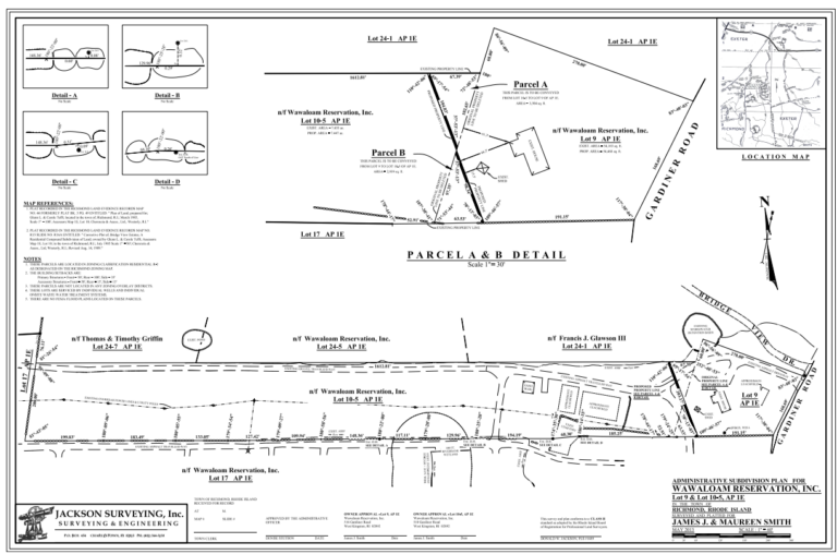
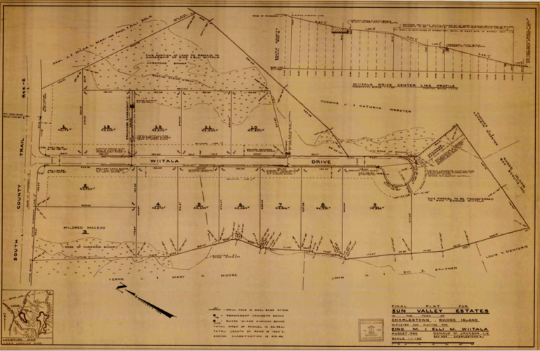
Subdivisions & Land Development

A subdivision of land allows an applicant to either divide their property into multiple parcels or reconfigure lot lines of existing lots. The three types of subdivisions are Administrative, Minor, and Major and all require approval through a municipality. Most administrative subdivisions which allow the relocation or reconfiguration of boundary lines are reviewed by the Towns Planner and do not require review by the Planning Board. However, minor and major subdivisions do require review by the Town’s Planning Board or Technical Review Committee thru a series of reviews categorized as Conceptual, Master, Preliminary and Final depending on the size and scale of the subdivision. Our firm provides a complete service for subdivisions staffed with both a professional land surveyor to handle the boundary controls and a professional engineer to handle any road and/or drainage designs.

Most commercial projects will require a municipal review under their land development or development plan review process. These projects consist of numerous design phases that include parameters such as parking lot layout, septic design, drainage design, landscape design, building layout, state permitting and eventually construction layout. Our firm is experienced in leading a project through the various phases and teaming up with attorneys, landscape architects, and planners.

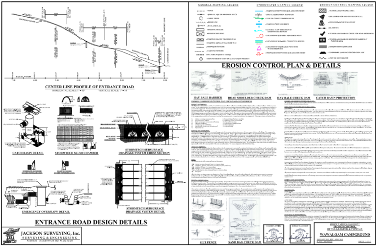
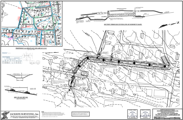
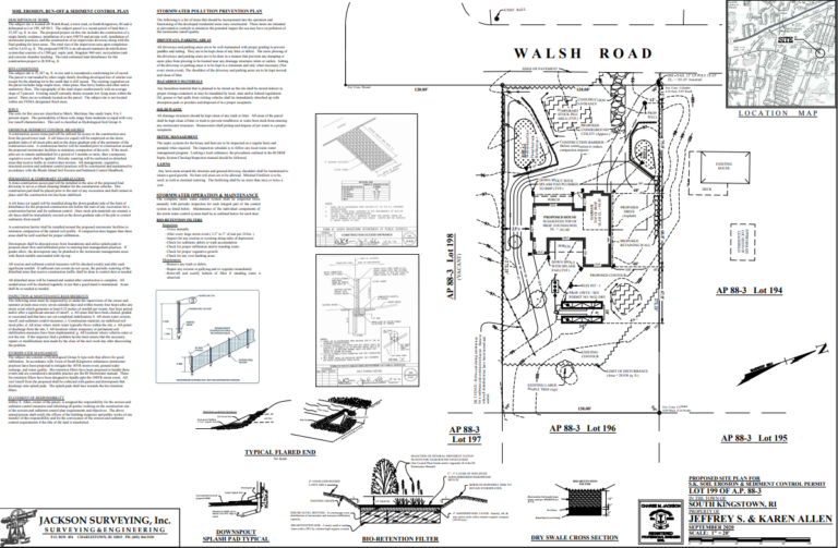
Stormwater & Soil Erosion

Most projects that have any sort of land disturbance, including residential projects, will require a form of soil erosion and sediment control (SERSC) design and/or stormwater management design. The scale of each design is based on the individual project and may even require permitting through the Department of Environmental Management if larger than 1 acre in size of land disturbance. SERSC consists of proper location of management practices like silt fences, construction entrances, stockpile areas, and sediment basins along with devising an operation and maintenance plan to be followed throughout construction. Stormwater design includes the design of best management practices that will handle stormwater runoff of numerous storm intensities on the site due to the increase in impervious surfaces and/or land clearing. Many residential projects will include the design of rain gardens, drywells, or vegetated swales to handle roof runoff. Larger projects will be required to follow the RI Stormwater Manual that outlines numerous different types of management practices and required standards.

Contact Us

Call us during normal business hours, leave us a voice message, or please fill out the online form and one of our staff members will contact you within 2 business days. Please note that for us to provide an estimate we will require a street address & town or tax map & lot numbers of the subject parcel along with a brief description of your project.